On the way home from another of my vagabonding trips, it
occurred to me that I’m going to all these “far-away,” exotic places and that I
had never been (except on the bus, of course) to the nearest city, Totogalpa. Actually, thinking of this as an excursion is
a bit of a misnomer, since I live in Totogalpa. However, I live in the
municipality of Totogalpa (probably analogous to a county in the US but smaller)
and there is also a city of Totogalpa. The
out-lying municipality is agrarian and is famous for tomatoes, while the city is
relatively indigenous in demographic make-up.
 |
| The sign entering the municipality of Totogalpa, proclaiming
that it is the leader in production of table tomatoes. This is about 1 km south of the Solar Center. |
Since it’s only 5 km, I walked there along the Pan-Am
Highway, and as usual was able to observe new things on the road: a compact pick-up truck loaded with 8
caskets, a truck that was piled 3-times higher than the roof of the cab (I’m
not sure how dense the load was, but the center of gravity had to be high!),
someone sleeping (at least lying down) on the top of a truck cab… Upon arrival, I learned that Totogalpa has just
over 10,000 residents, about the size of Platteville. I also noticed that it had a sidewalk along
the highway and that it was relatively accessible to wheel chairs—a first for
Nicaragua. The highway passes through
the east edge of town and has a few shops, an Assembly of God church, the
hospital and a few housing developments.
The site of an ancient village (circa 400 A.D.) has been identified just
to the northeast of town, but it has not been excavated thoroughly; there are plans for a future museum,
however.
 |
| Entry sign on the Pan-Am Highway for Totogalpa. Such signs on secondary roads are
non-existent. |
 |
| A picture of the almost-ADA-compliant sidewalk. Really impressive for Nicaragua, however. |
 |
| One thing that’s evident in Nicaragua is that if any
progress is made, there must be a sign or a plaque commemorating and honoring whoever was
responsible. Here is a very nice plaque
commemorating the building of the sidewalk. In the
background is a new housing development with a standard, basic design. There are a number of these I've seen in various locales. |
As all the cities I’ve visited so far, the church dominates
the skyline and sits at the center of town, facing west, with a central park
just across the street.
On the way to
the church, one passes an intersection with a statue of Mary Magdalene, the
patron saint, and a plaque declaring Totogalpa as the “City in the Nest of Bird”
and announcing the annual celebration to Mary in July.
It appeared to be “the” place to be on a
Saturday morning, with several dozen folks hanging around and the bicycle ice
cream vendor more or less parked there.
Arriving
at the mid-18th century Church of Santa Maria Magdalena, one sees that it is currently under fairly extensive
restoration, as is evident from the scaffolding surrounding the bell tower.
It is interesting that this preservation is funded by the US government to the tune of about $110,000 over the past two years, (For details, go to:
http://nicaragua.usembassy.gov/nt_1000722_afcp_totogalpa.html) With the renovation work, it was impossible to
visit the interior, but it appears that the sanctuary is still available for
Sunday mass.
It
 |
| Intersection with the statue of Mary Magdalene. There are a lot more “loafers” off to the
left, along with the Igloo man. |
 |
| Close-up of the
statue. Note the wire bird’s nest at the
bottom to represent Totogalpa as being in the nest of the birds. |
 |
| View of the front
of the church. Mornings are just not a
good time to get pictures of Nicaraguan churches as the there is always
back-lighting. |
 |
| Close-up of the scaffolding on the church tower. I don’t think this would pass OSHA
inspection. |
The park was again different that any I’ve seen before. It was smaller than the others and more dominated
by kids’ play equipment/activities: a
basketball court (but with both hoops missing), swings, climbing equipment and
a library. At the center was a statue I
presume to be of Mary Magdalene. (The
statue was unmarked and appeared to have feminine features, but it also seemed
to have a crown of thorns, so I’m not really sure what to make of it.) Surrounding the park was what appeared to be
a typical mix of shops, although Totogalpa appears “sleepier” that the other
places I’ve visited. However, it may just
have a smaller population—cities not on the Pan-Am don’t have nice population
signs like Totogalpa.
 |
| A view of some play equipment with the basketball court
in the background. The damaged backboard
is directly below the street light if you look closely. |
 |
| I normally don’t
like the word “cute,” but I think it’s an apt description of the library. |
 |
| The stature in
the middle of the park—Mary Magdalene…or not. |
In wandering down side streets, I found the secondary school
(where Sabana Grande kids must go after 6 th grade), the cemetery and very
impressive, though completely unmarked, religious shrine of some kind. There was also an interesting a mural or two,
something that seems very common as a means of artistic expression here.
 |
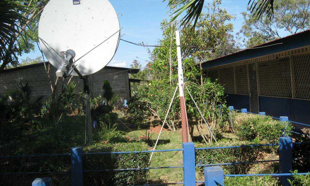
| A view of the
secondary school. It consists of several
building around this central courtyard.
They obviously have some kind of satellite service (or at least did…or
at least were intended to have such). |
 |
| A very elaborate
grave for a couple of young folks. There
are even pictures included. |
 |
| The unknown shrine
not far from the cemetery. It seemed
worth a picture even though it had no markings and I don’t know what it’s
for. Somebody was moved by something. |
 |
| A mural on a
downtown building. The left touts
Totogalpa's location on the Ruta Sandino (a tourist-promotional route that
traces places important in the life of Augusto Sandino; somewhat like our Great River Road or Mormon
Pioneer Trail designations in the US) and the right side promotes the tomato
crop. Over the door is the slogan “in
the nest of the birds.” |
 |
| The local
campaign headquarters for the Sandinista party (FSLN). Here in the north, I’ve only seen one
building used by another party and only a handful of campaign signs. Note the image of Che Guevara on the left. |
The last item is from the guidebook, but I didn’t pursue it
since I also wanted to get to Ocotal to do some errands—maybe next time. Just north of Totogalpa is a mountain (Cerro
de las Rocas) along the Rio Coco (the one that goes through Somoto
Canyon). In this mountain is the “Cueva
del Duende,” or “Cave of the Leprechaun/goblin/elf.” The north of Nicaragua is apparently full of
legends relating to duendes, a race of small demonic, alien beings who are in league
with the devil and wreak all kinds of havoc on good folk, but they are
especially keen to snatch babies who haven’t yet been baptized. If it’s a stand-up-and-walk cave, I might try
this before leaving—if it’s a slither-on-your-stomach-like-a-snake cave, probably
not!
Final note: I already
disproved my thesis in the “Bus” posting that “there’s always room for one more”
as I left for Ocotal. Only about 10 of the
25 or so waiting were able to get on the bus (and several were on the rear
bumper and hanging out the front door. However,
I think that bus was very late (and hence fuller than usual) as the next bus
came within 3 minutes and was relatively uncrowded. I bet, though, if this had been on a route
with only 1 or 2 buses a day, we would have somehow all fit in (or on).


oh come on, Dad! Where's your sense of adventure? "Slither-on-your-stomach-like-a-snake" caves are awesome! I think you should explore this cave, regardless of what kind it is!
ReplyDelete